MINTO PARK
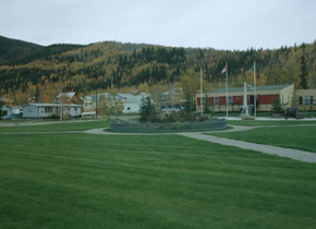
• Victory Garden with central Victorian style garden planted primarily with indigenous species such as wild rose, delphiniums, poppies, pansies and snapdragons and bordered by a 19-sided picket fence • Geometric design containing the garden with a circular white gravel path from which diagonal paths radiate outwards to the corners of the lot, forming triangular quadrants of lawn north of the OTAB • Location and setting of the Obelisk-shaped Cenotaph war memorial flanked by trees and field guns on the east side of Victory Garden • Formal landscape bordered by wooden boardwalk along 5th Avenue and Church Street with the OTAB prominently centered • Balsam poplar and white spruce bordering Fifth Avenue and Church Street • Open, level area south of the OTAB including playing field and expansive lawn
Construction Period: From 1896 to 1905 Designation Level: Municipal
Minto Park is designated as a municipal historic site for its social, historic and aesthetic values. Designed to complement the neoclassical architecture of the OTAB, the legislative and administrative headquarters of the Yukon Territory from 1902 until 1953, Minto Park is Yukon’s first formal park and a landmark within the community. Established in 1904, Minto Park was named after the first Governor General that visited the Yukon, Governor General Gilbert Elliot-Murray-Kynynmound, the 4th Earl of Minto.
The formal landscape and expansive green space contribute to the heritage character of the OTAB, emphasizing its stature and architecture within the community. The designed green space surrounding the OTAB is typical of the federal government properties constructed during the early twentieth century within the Government Reserve.
Minto Park was developed in cooperation with the Dawson Horticultural Society to provide a formal green space and recreation area that showcased a strong federal presence. Beginning in 1903, the drainage, leveling and landscaping of the area around the OTAB along with the construction of a grandstand, ball park and tennis courts helped reinforce the site not only as the administrative centre of the territory, but also as the social and recreational focal point of the community.
Since its inauguration, the park has been the town’s venue for athletic games, military drills, community celebrations and events, and represents an important aspect of the community’s history. One of the few formal green spaces in Dawson, Minto Park contributes to the heritage character of the Government Reserve area and continues to play an important role within the community.
In 1910, a central flower bed was installed in the park north of the OTAB that was replaced by a granite cenotaph in 1924 to honour Yukon soldiers who fought in the First World War. Thereafter this area was known as ‘Victory Garden’. A community initiative reconstructed the Victory Garden and lawn in 1992 using a period landscape plan. The garden was compressed into the western half of its former space and the geometric design with paths, central flower bed and lawn bordered by alternating poplar and spruce trees along Fifth Avenue and Church Street were restored. The cenotaph remains in its original location in what was once the center of Victory Garden and is flanked by two field guns that were installed in 1924 as part of the memorial. The Victory Garden and Cenotaph provide a tangible link to the sacrifices Canadians made in the First and Second World Wars.
Minto Park has been recognized for its heritage and social value by the City of Dawson, Bylaw #13-07.
Character Defining Elements
• Victory Garden with central Victorian style garden planted primarily with indigenous species such as wild rose, delphiniums, poppies, pansies and snapdragons and bordered by a 19-sided picket fence
• Geometric design containing the garden with a circular white gravel path from which diagonal paths radiate outwards to the corners of the lot, forming triangular quadrants of lawn north of the OTAB
• Location and setting of the Obelisk-shaped Cenotaph war memorial flanked by trees and field guns on the east side of Victory Garden
• Formal landscape bordered by wooden boardwalk along 5th Avenue and Church Street with the OTAB prominently centered
• Balsam poplar and white spruce bordering Fifth Avenue and Church Street
• Open, level area south of the OTAB including playing field and expansive lawn
Description of Boundaries
Victory Garden north of the Old Territorial Administration Building (OTAB) and the land south of the building including the playing field, lawn and playground, excluding the Block 4, OTAB Heritage Reserve.
Historical Sources Location
City of Dawson- Municipal Designation Nomination Form- Minto Park
Old Territorial Administration Building National Historic Site of Canada Commemorative Integrity Statement, 2005,
Dawson City Museum- Historical photographs
1994.15.3.89- Victory Garden c1920s
1994.123.43- Cenotaph, August 1929
1995.345.22- Flood in Dawson City, Victory Gardens, c1930
1996.39.13- Baseball game at Minto Park, 1900
1996.39.58- Flood of May 1925, people canoing through Minto Park between 5th and 6th Avenues
1997.213.1.6- OTAB c1918 showing Minto Park
1997.213.1.47- Discovery Day celebrations, Minto Park, 1920
1997.213.1.49- Discovery Day Celebrations, Minto Park, 1920
1997.299.5- Baseball Game Minto Park, c1904
1979.3.1.5- Baseball Game Minto Park, c1905
1979.3.2.11- Baseball Game in Minto Park, c1910
1979.3.3.20- Slow bicycle race, c1910
1983.182.2.3- A gathering in Minto Park, c1925
1983.186.5- Minto Park during flood of May 7, 1944
1984.138.2- Tennis Club at Minto Park, July 1901
1990.43.200- Hammering Contest at Minto Park, c1910
1995.155.2- Canadian Rangers, c1920
1994.259.1- South Dawson City, c1910 (showing victory garden and Minto Park)
Cultural History
Three years after the OTAB was completed, the rough frame buildings located on the corner of Church Street and Fifth Avenue in the Government Reserve were removed and a formal park was established. It was named Minto Park after the Canadian Governor-General. William Horkan, an Irishman and naturalized American, came to the Klondike in 1897 and was awarded the initial landscaping contract. The front lawn was landscaped and there were playing fields to the south used for military drills, sports and public events.[13] Tennis courts were also established to the southeast of OTAB, and gave rise to a thriving tennis club in the early part of the 20th century. A baseball diamond complete with bleachers was built in the south end of the park.[ 14] There is also a concession building. Since 1979, the main stage of the Dawson City Music Festival has been located in the park.
Established in 1904, after lobbying by the Horticultural Society of Dawson, the formal garden was meticulously maintained for decades and was a testament to the pride felt by the community. [15] Historic photographs show that the central flower bed was in place in 1909, however it likely existed earlier (approximately 1903), and was approximately 13 meters in diameter. [16] Around 1913, the flower display lost its fence, and in 1924 the flowers were replaced by a granite Cenotaph on a circular grass bed.[17] Accompanied by two field guns, the memorial was dedicated in honor of the soldiers who fought in World War I [18], and the formal park became known as “Victory Garden”. The garden and Minto Park were leased to the City of Dawson for community recreation and the eastern half of the original garden was taken over by a nursing station. The garden and Cenotaph were restored in a reduced size in the north corner of the former park in the 1980s and over-mature trees were removed from the front lawn.. The area was restored again in 1992 based on a professional historic period landscape plan. A new foundation was installed under the Cenotaph in 1993-4.[19]
In the 1992 plan the outside perimeters of the restored garden were compressed into the western half of its former space but the geometric design and overall impression is almost identical. The original granite Cenotaph remains at its original location, where the central flower bed had first been installed (now the east edge of the garden). The central flower bed is an accurate replica of the original, enclosed by a 19-sided picket fence, and planted with flowers and shrubs graduated in height from tall in the centre to lowest at the edge of the bed. Restoration with these minor modifications was facilitated by historical photographic evidence as well as on-site physical remains such as trees, shrubs and grades.[20] The setting has evolved and there have been developments such as a new hospital to the west and a train shelter to the south. These structures have compromised the integrity of the view planes from Church Street and Sixth Avenue, but the front elevation view planes of the site from Fifth Avenue are essentially intact.
The formal landscaping around the OTAB is integral to its presentation as a landmark within the community. Minto Park is a central feature to Dawson City and is instantly recognizable to community members. Minto Park, Fort Herchmer and the dyke are the only three expanses of green public space contained within the townsite.
The Royal Canadian Legion and Dawson Rangers hold a portion of the Remembrance Day ceremonies every year at the Cenotaph on the east side of Victory Gardens. This tradition acknowledges Yukoners' courage and contributions to Canadian military efforts and has deep meaning to many Yukon families who made great sacrifices during the two World Wars, the Korean War and subsequent wars. For these reasons, it is also a site of pilgrimage.
In summer, Dawson City Museum interpretive programs spill out to the exterior of the OTAB. The museum plays host to the annual and highly attended Canada Day celebrations on July 1st and other community events which are held on the surrounding landscaped green spaces.
The Royal Canadian Legion has been associated with Victory Garden since the 1920's. Frank Berton, father of well-known author Pierre Berton, was instrumental in raising funds to install a memorial at the site. The Great War Veterans Association dedicated the Cenotaph on September 24, 1924. This organization later became the British Empire League and then the Royal Canadian Legion and remains active in the Dawson community.
Citations:
12: From City of Dawson Municipal Designation file.
13: Historic Sites and Monuments Board of Canada Submission Report – Place: The Old Territorial Administration Building, Dawson, Yukon, 2001-06, p. 255.
14: Dawson City Museum, Frederick Nelson Atwood fonds, photograph 2006.33.1.289.
15: Fardin, Linda, Yukon Territory Administration Building, Dawson City Yukon: Period Landscape Study, (Parks Canada Engineering and Architecture,1984), pp. 2 & 8.
16: Ibid, p. 6.
17: Old Territorial Administration Building National Historic Site of Canada Commemorative Integrity Statement, op.cit., p. 16.
18: Fardin, Linda, op.cit., figure 13.
19: Myrna Butterworth, personal recollection, 2013.
20: Fardin, Linda, op.cit., p.6
Documentation Location
File 3630-40-03, Historic Sites, Cultural Services Branch, Government of Yukon.