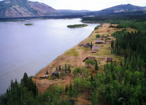
FORT SELKIRK
Lot 1021, Plan 2008-0123 LTO YT
Construction Period: Pre 1895 Designation Level: Territorial
The Selkirk First Nation Final Agreement requires that Fort Selkirk be designated as a Yukon Historic Site to commemorate its heritage significance to all people of the Yukon.
Fort Selkirk is set in a pristine, river valley rich in natural resources and surrounded by a mountainous, boreal landscape with a dynamic geological record. There is an intangible, aesthetic and emotional attraction to the site that exudes a sense of community secured within a rugged and visually striking environment. Fort Selkirk illustrates the unique contribution and combination of different cultures and natural environment that has helped form the social, economic and political fabric of the territory
The site also illustrates the historic trading economy, the transportation development of the Yukon, the sovereignty of Canada, the early expansion of the church and community life in a northern isolated area.
Fort Selkirk is central to the homeland of the Northern Tutchone and their cultural traditions such as game harvesting, trade and travel. This place has been a traditional harvesting and gathering site for thousands of years. Its importance as a place for meeting and trading between First Nations is evidenced by a network of traditional trails and archaeological artifacts. It is the first place where the Northern Tutchone people encountered and hosted colonists from afar. The site was given its English name by Robert Campbell of the Hudson's Bay Company, who established a trading post here in 1852. The aboriginal name for the place has been lost over time. Although short-lived, the post signified the beginning of an era as a Yukon centre of commerce and communication with the outside world. It continued as a hub of land, river and later, air transportation until the middle of the 20th century.
A permanent community evolved in the early1890s with the establishment of Arthur Harper's trading post and an Anglican Church mission. The community grew quickly as thousands of stampeders headed for Dawson City during the Klondike Gold Rush in 1896. The strategic location of Fort Selkirk led to its use as a base for the Yukon Field Force and a North-West Mounted Police post in 1898, and its consideration to be the first Capital of the Yukon Territory. Throughout the first half of the 20th century Fort Selkirk remained a stable, thriving community where two cultures lived, worked, played and prayed together. Abandoned in the 1950s due to the construction of modern roads and the end of sternwheeler traffic, members of the Selkirk First Nation and other Yukoners continue to think of it as their ancestral home.
The partnership between the Selkirk First Nation and Yukon governments as co-owners and co-managers of the site illustrates the continuing spirit of deep and cooperative care for Fort Selkirk.
Source: Heritage Resources Unit File #3630 32 02 04
Character Defining Elements
Character Defining Elements include:
- 37 standing, historic structures, their components and their relationship with each other in a linear arrangement facing the Yukon River.
- Fenestration, roof styles and floor plans of the standing buildings.
- Wood frame windows and doors, interior finishing and exterior finishes such as roof and wall cladding, log wall construction
- Two well maintained cemeteries
- Archaeological evidence of prehistoric and historic use and occupation.
- A collection of prehistoric and historic artifacts
- A combination of natural and culturally modified landscape features including the open, grassy meadow surrounding the historic town site, the vestiges of the historic and pre-historic trails, and the rugged uncultivated riverbank
- Viewscapes of the Yukon River, Tthi ts'achan (Victoria Rock) downstream, Meghliu (the basalt cliffs on the opposite bank) and Nelruna (Volcano Mountain) and mouth of the Pelly River upstream
- Proximity to the Yukon River in a healthy riparian zone supplying natural resources for food, clothing, fuel and shelter
- Location where travel routes converge and where people, migratory salmon and wildfowl pass through
Description of Boundaries
Lot 1021, Plan 2008-0123 LTO YT
Historical Sources Location
Yukon Waterways Survey - Parks Canada 1972
Ft Selkirk Oral History Project - Heritage Branch 1985
Ft Selkirk Brochure - Heritage Branch
Yukon Government Historic Sites Unit: Research Information, Reports, Plans, Maps, Photographs
Cultural History
Fort Selkirk was a trading nexus long before European traders entered the Yukon. The Northern Tutchone of the Fort Selkirk area were part of a trade network that extended far to the south and north, from the Arctic Ocean to the Bering Sea. The Chilkat people of present day Haines and Skagway, Alaska controlled the Pacific Coastal passes into the Yukon and thus the trade with the Russians who visited the Alaska coast. The Chilkat ventured far inland every year on a trade route that took them as far north as Fort Selkirk. They enjoyed a monopoly on European trade goods moving into the Yukon and the furs and hides that moved out.
Enter the Hudson’s Bay Company, which made its first trading foray into the Yukon establishing a post at Frances Lake north of present day Watson Lake in 1842. Four years later, Campbell built Fort Pelly Banks on the Pelly River. Proceeding along the Pelly, Campbell came to the Yukon River and established the first post at the confluence across the river from the current Fort Selkirk in 1848. To remain relatively inconspicuous, the post was built on a low flood plain back in the woods. Unfortunately, the site was prone to flooding and ice damage, forcing Campbell to relocate the post to its present site in 1851.The Chilkats, upon discovering the post and the threat to their trade monopoly, rousted the Hudson’s Bay traders and plundered the post in August of 1852.
The remains of the first post were located by Yukon Archaeologist Ruth Gotthardt in 1989 and a full archaeological dig was undertaken in 2006 by Victoria Castillo.[31]
Non-native traders remained absent from Fort Selkirk until Arthur Harper and Joseph Ladue built a post here in 1889. By that time, prospectors and traders along the Yukon River had become much more common and the Chilkats were allowing outsiders to cross through the coastal passes.
Once the Harper post was built, the Anglican Church soon followed, building a church and rectory at Fort Selkirk in 1892-93. Soon, Fort Selkirk became a distribution centre for Pelly and South Macmillan rivers. Several stores were set up at Fort Selkirk over the years including the Dominion Hotel and Store, Horsfall’s, Taylor & Drury, Schofield and Zimmerlee’s, then the Hudson’s Bay Company again in 1938.
With tens of thousands of people heading to the Klondike gold fields, the Canadian government had a legitimate concern about maintaining law and order. Of particular concern was the number of Americans crossing over the border from Alaska. In addition to strengthening the North-West Mounted Police presence, the Canadian government sent 200 troops of the Yukon Field Force to ensure order and Canadian sovereignty. The force arrived at Fort Selkirk in 1898 and erected 11 large log buildings, complete with a central parade square, on the east side of town. The force was commanded by Lt. Colonel Thomas Dixon Byron Evans, Royal Canadian Dragoons. A detachment of two officers and 50 men were sent to Dawson City in October 1898. Duties included guarding gold shipments, ceremonial duties, and some patrolling.
The North-West Mounted Police set up a detachment at Fort Selkirk in 1898. It was one of a series of posts set up along the Yukon River and in the mining settlements during the heyday years of the gold rush. With mining activity decreasing and people leaving the territory, the post shut down in 1911. The RCMP reopened the post in 1932 under Corporal G.I Cameron until 1949. Cameron went on to become the Sergeant at Arms for the Yukon Legislature. His daughter Ione, who spent her youth at Fort Selkirk, later became mayor of Whitehorse, commissioner of Yukon, and the Yukon’s senator.
Nearby, three km to the west, was Swinehart’s farm. William Swinehart and his family began the farm in 1898 and farmed it for 16 years. The farm was renowned for potatoes which they sold in Dawson City in the spring as soon as the river opened. They got theirs to market three weeks before the boats from Whitehorse were able to make it downriver. In 1903, the farm produced 11 tons of potatoes, 9 tons of which went to Dawson and were sold out within 6 hours. The farm also made a good profit selling hay to the roadhouses for the horses traveling the Dawson-Whitehorse winter road.
Two of the men working with Swinehart, Frank Chapman and Billy Thompson, later established Pelly Farm 7km up the Pelly from Fort Selkirk. Under brothers Dick and Hugh Bradley, this would become one of Yukon’s earliest and most successful experimental farms and longest running weather stations. It is connected to the Klondike Highway via a 40km single lane gravel road and therefore acts as a launching point for visitors and work crews going to Fort Selkirk.[32]
Stabilization work began at Fort Selkirk in the late 1970s. It was the Yukon government’s earliest and largest preservation project, which continues to this day. It is also a model for cooperative heritage management between the Yukon and First Nations governments.
Citations:
31: Fort Selkirk: Early Contact Period Interaction Between the Northern Tutchone and the Hudson’s Bay Company in Yukon, Occasional Papers in Archaeolgy No. 17, Victoria Elena Castillo.
32: Yukon History Trails, The Swinehart Farm, by Gord Allison https://yukonhistorytrails.com/2018/07/02/the-swinehart-farm-part-1-introduction-from-wisconsin-to-the-yu kon-1896-98/
Documentation Location
File 3630-50-17 Historic Sites, Cultural Services Branch, Government of Yukon